5.4.3 Import GIS data from AutoCAD - LUPMISManual
Main menu:
5.4.3 Import GIS Data from AutoCAD
Level of expertise required for this Chapter: Advanced; general Map Maker training
TCPD has many ‘sector layouts’ (Local Plans) in AutoCAD format. It is envisaged, to convert all these drawings to geographically referenced data at LUPMIS, which can be correlated and linked to other GIS data. Three different approaches (through DXF or DWG files) are explained below.
Be aware, that most AutoCAD files are not georeferenced and have incomplete topology (for example, lines are not snapped, polygons still to be converted from lines, etc). Additional editing work is required to make use of those in the GIS.
See also Chapter 8.2.10.
- - - - -
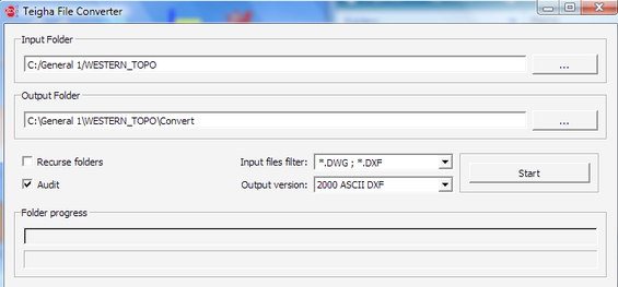
1. Convert the DWG or DXF file into DXF file with format ASCII2000:
Freeware utility 'Teigha File Converter' has to be installed in your computer. It is available on the LUPMIS installation file and resides, after LUPMIS installation, in your folder LUPMIS\GISUtilities.
Define input and output folder in 'Teigha' and choose output version '2000 ASCII DXF'. It will then run a batch conversion of all DWG / DXF files.
2. Import the DXF file with selected layer to Map Maker:
If there is more than 1 layer in your drawing file, you can select, which layer should be converted to DRA file. The import runs as: Main menu > Utilities > Vector utilities > Import files > DXF (ASC rel.14) > Import AutoCAD ... window: Choose file ...: Choose source DXF file > Select DXF file of previous step > Open > Next step > Choose features type: De-select all (1 in graphic below) > Select layer to be imported (2) > Next step (3) > Name target window: Choose target file > Enter name of new DRA file > Save > Finish > Confirm save

If the source file is in UTM, the conversion is complete.
3. Conversion from War Office to UTM 30:
3a. If the source file is in War Office (feet or meter), you have to convert it to UTM 30. First, check if it is in feet or meter: Display the converted DRA file from step 2, measure a known distance and see if it approximately the same as in UTM. If the distance in the converted file is roughly 3 times as much, it is in feet and you have to convert it to meters: Load it into Live Layer, then right-mouse > Live layer actions > Transformations > Convert feet to meters, and save it under a new name.
3b. For the conversion to UTM, your Map Maker must be set up with the War Office projection. See Annex 8 how to configure Map Maker.
The converion starts with Main menu > Utilities > Latitude and Longitude utilities > XY file to another projection > Vector > Choose source map projection: WarOffice > OK > Select file from previous step > Open > Choose target map projection: UTM30 > OK > Enter name for new file > Save
- - - - -
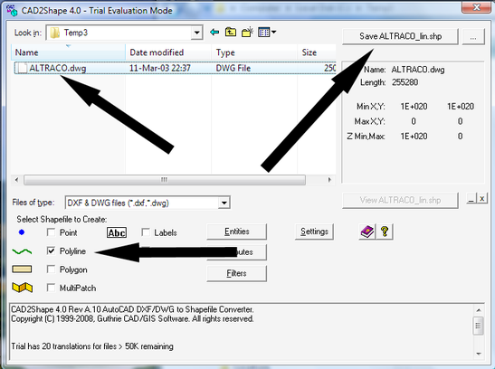
Alternative: If you have received a drawing file (DWG file) of AutoCAD, but can not convert it to a DXF file, you have to use a GIS utility program:
1. Convert DWG file to SHP with a utility program, which is available at the Internet or from TCPD-HQ / LUPMIS either as freeware or shareware for a small fee. Contact HQ for the latest support (email below).
Current favourite is the shareware CAD2Shape (see also Annex 7 for installation of GIS utilities). Purchase directly from the internet or contact TCPD-HQ / LUPMIS.
Select folder and file > Select Polyline (or Polygon) > Save …. shp
- - - - -
2. Convert the SHP file to DRA file.
Follow Chapter 5.4.1 for a description of the process. At the Import ArcView Shape file, step 2 window, you don’t have to tick ‘Import database’, because AutoCAD drawings do not have an attached database.
- - - - -
3. Edit the line / polygon map.
At Map Maker, load the converted DRA file, and have a look at the lines/polygons. You might have to copy it to live layer, and edit, i.e. snap lines, delete lines etc.
- - - - -
4. Georeference the map.
Follow Chapter 5.2.5 on georeferencing the map. In most cases, it will be sufficient to have two reference points, of which the coordinates are known.
- - - - -
5. Check the data.
Like any other converted data, also drawing files have to be quality-checked. Overlay known correct features to the map, such as GPS-tracked roads.

