8.2.3 Streetname + housenumbers - LUPMISManual
Main menu:
8.2.3 Streetnames and Housenumbers
Level of expertise required for this Chapter: Intermediate; specifically for LUPMIS @ TCPD
Street names and house numbers are the numbering system of parcels for the public. They form a generally understood address systems in most countries of the world.
Following functions are available under Drawing Tools > UPN / Street names:
a) House Numbers
The entire process for Local Plan preparation with planning units, UPN, street names and house numbers is illustrated, starting at the previous page (Chapter 8.2.8) and is displayed at Drawing Tools > UPN/Street names > Procedure.
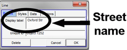
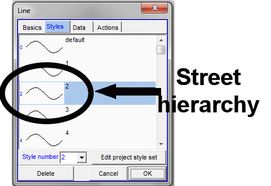
In step 3, you have to digitize the 'centre lines' of the streets with as few points as necessary, in the correct direction, i.e. away from the main road. You can easily cross other streets. For each street, enter the street name as 'display label' and the hierarchy of the street as style (e.g. 1 for the main road, high style number for minor roads).
Save this file under the name of the Local Plan file name with '_streetlines', e.g. Papaase 2_streetlines.dra.
After this preparation, you run this 'Housenumbers' Tool (step 4):
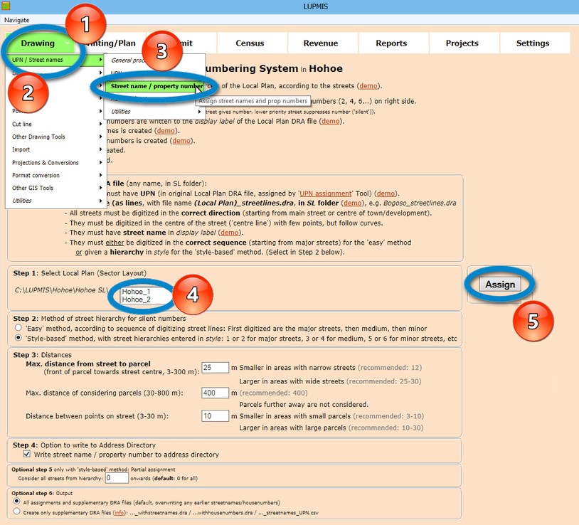
Select the Local Plan and define the distances:
Distance between points on street: Your centre line street will be cut into small pieces. As a general rule, it should be around 1/3 or 1/4 of the length of the parcels. The default is 25 m, which is fine in very most cases.
Maximum distance of considering parcels: How far away fróm the street do you want to check the system for parcels to be numbered. The default is 400 m, which is fine in very most cases.
Maximum distance from the street (centre line) to the nearest part of the parcel (front of the parcel) (default: 10 m). If your first attempt appears to leave out some parcels from numbering, repeat this step with a larger distance.
In most cases, you can accept the default distances.
If you don't have the corresponding '_streetlines.dra' file in the same folder, it will not work.
This Tools creates 3 additional files:
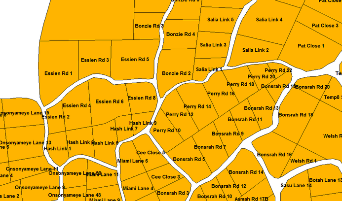
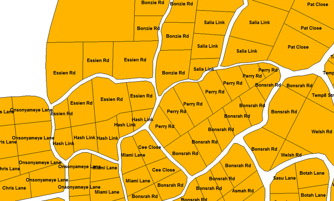
Local Plan as parcel map with street names only, in file (Local Plan)_withstreetnames.dra (see example below) in the SL folder
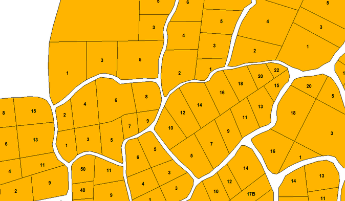
Local Plan as parcel map with house numbers only, in file (Local Plan)_withhousenumbers.dra (see example below) in the SL folder
Reference table UPN - street name / house numbers, in file (Local Plan)_streetnames_UPN.csv (for ímport to Excel) in the SL/Tools folder
It also updates the Address Database.
Additional option of 'Partial assignment': If you have earlier assigned the major street with house numbers, and they are fine, but you want to re-assign the lower priority streets with new numbers, you can enter a value of priority in 'Considering all streets from hierarchy'. E.g. if you enter 6, then all streets with a lower hierarchy (numbers 6 and higher) are re-assigned.
Additional option of 'Only create supplementary DRA files': If you have earlier assigned all parcels with street names and house numbers either manually or automatically, and want to leave them as they are, but create the additional 3 files, click on 'Create only supplementary DRA files'.
Remark: You can assign street name and house number manually to a parcel (field 'display label') or edit manually after an automatic assignment, but you must follow the street naming syntax (see Annex 10.1). If you add a property number in a row, but don't want to change the following numbers, you can give a number with ....-1, ....-2 etc, e.g. 24-1 after 24. And, you always have to re-run this Tool with option 'Create only supplementary DRA files'.
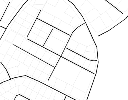
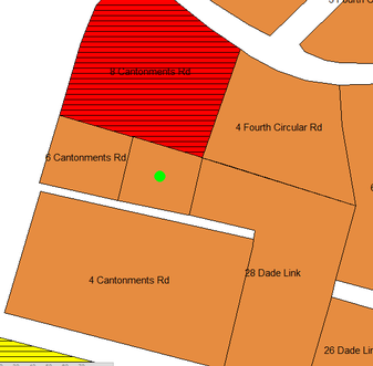
In the first attempts running the House Number Tool, you might encounter a message that some parcels have not received a house number and a map showing green dots on those parcels (see below). You then have to check, if these parcels have a street (in '_streetlines.dra') next to (if not digitize a street, such as in the example below) or you have to increase the defined distance from street to parcel.
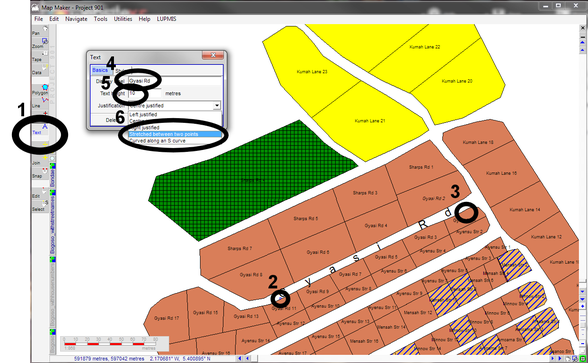
Optional step 5 of the Local Plan processing is to write the street names as text in Map Maker: Use the text tool in Map Maker, locate begin and end of the label on the map, enter the street name and text height (standard: 10), and save it as (Local Plan)_streettext.dra in the SL folder.
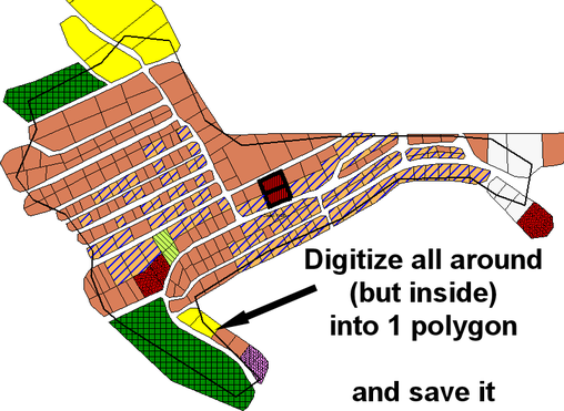
Optional step 6 of the Local Plan processing is to compile the entire coverage of streets into a polygon, to be saved as '(Local Plan)_streetpoly.dra' in the SL folder.
Process is to first digitize one polygon around the Local Plan, but 'inside' the parcels:
Then, you overlay this DRA file with the Local Plan DRA file with the Drawing Tools >Other GIS Tools > Overlay > Start > Choose polygon files to intersect > (Select files) > ..... > Run > Save As > Define file name > Save > Done: OK > Close window
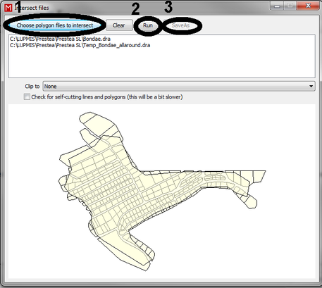
This 'streetpoly' file works also as quality-control check: Unexpected lines getting out from the street polygon indicate, that the adjacent polygons were not 'snapped'.
If you want to upload this 'streetpoly' file to the Internet (e.g. as KML file, see Chapter 6.10.1), you have to break ('cut') it into many polygons, to avoid any 'islands'.
For overlay operation in general, see Chapter 8.2.10.
Another optional step (7) is the possibility to digitize the points of streetname signs into the Local Plan, saved as '(Local Plan)_streetpoints.dra' in the SL folder.
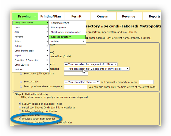
b) Address Directory
For a full description of the address directory see the specific Chapter of the Address Database with its entry options (Chapter 9.7.1) and retrieval options (Chapter 9.7.2).
You can list the references of UPN numbers to the street name / housenumber system and v.v. The list has been generated by the 'House numbers' Drawing Tool (see above) and is also saved in the Address Database.
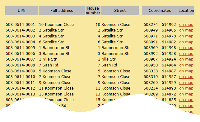
Instead of the entire list for the whole District, you can also select one specific UPN or for one specific street name / house number. It will then display the corresponding number(s).
Change Street Name
This Tool is listed under Drawing > UPN / Street names > Utilities > Change street name / code and makes the change from a previous street name (such as a 'street code') to a final street name easier. It changes the street name in all related DRA files and databases.
Be sure, that the first letter of the new street is uppercase, the following letters lowercase, and use abbreviation, whenever possible (not ACCRA STREET, not Accra Street, but Accra Str).
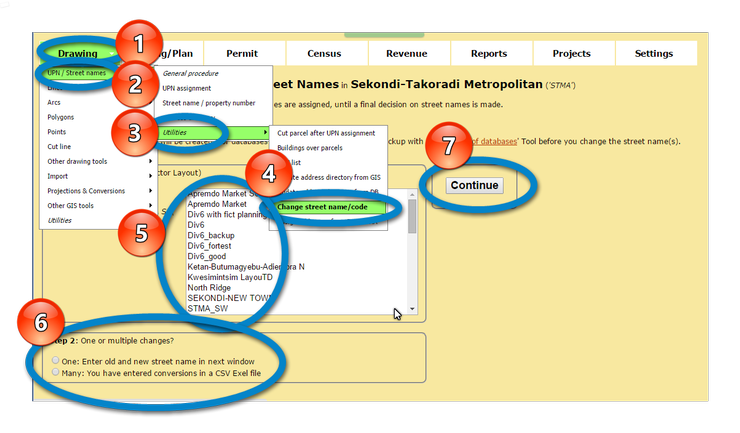
Old street name are kept for archive purposes still in the system (can be viewed through 'Address Directory'):


c) Change Street Name
This Tool is listed under Drawing > UPN / Street names > Utilities > Change street name / code and makes the change from a previous street name (such as a 'street code') to a final street name easier. It changes the street name in all related DRA files and databases.
Be sure, that the first letter of the new street is uppercase, the following letters lowercase, and use abbreviation, whenever possible (not ACCRA STREET, not Accra Street, but Accra Str).
Old street name are kept for archive purposes still in the system (can be viewed through 'Address Directory'):