A17.1 Exercise 1 - LUPMISManual
Main menu:
Annex 17: External Exercises
As a general training session and introduction to the modeling capacity of Map Maker, following training session can be used. This exercise is done with fictitious data (on LUPMIS CD), not specific for Ghana. Source of this exercise is external (from lt www.mapmaker.com and www.latitudecartography.co.uk ).
A17.1 Exercise 1
Two layers: Soil types and social economic categories. Question is to give the percentage of hectares that are owned by poor people with brown soil types.
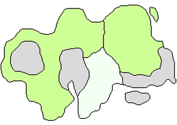
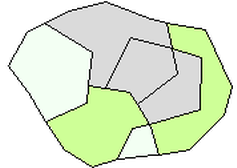
1. Start with two DRA files containing polygons. In this example one called socioeconomic.dra and the other called soils.dra. The two layers are shown here side by side but in reality they overlap each other.
Associated with each there is a database, in this example DBF files, socioeconomic.dbf and soils.dbf.
The socioeconomic database contains two columns:
“ID” containing the object ID for each polygon in the corresponding DRA file.
“WEALTH” containing an integer code for the wealth category.
The soils database also contains three columns:
“ID” containing the object ID for each polygon in the corresponding DRA file.
“SOILS” containing an integer code for the soil category.
“HECTARES” containing the polygon areas.
Your databases may contain different or more columns and different names. There is nothing special about the names chosen for this example or their order.
The Approach
The approach is to create a new DRA file and a new DBF file that represent all the polygons that are created by intersecting the socioeconomic polygons with all the soil polygons – in other words a set of contiguous non-overlapping polygons For each of these new polygons the database will contain data both on wealth and soil type. Once this new layer has been created we can determine what proportion of the polygons have both wealth of a particularly category and soil of a particular category.
This is a three step process:
Step 1. Go to Utilities > Vector utilities > Intersect / Unite files
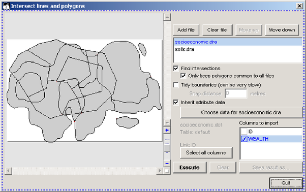
In the dialogue box that appears click on Add file and choose the socioencomic.dra file. Click on Add file and choose soils.dra. Tick the check box Find intersections. Tick Only keep polygons common to all files (this is not essential but it means you dispose of irrelevant polygons).
Select socioeconomic.dra in the list at the top, then tick Inherit attribute data, then click on the Choose data for socioeconomic.dra button. A pop-up dialogue box will ask you to select the link column – in this case “ID”. You are returned to the main dialogue; select the columns to import. In this case choose “WEALTH”.
Select soils.dra in the list at the top, then tick Inherit attribute data, then click on the Choose data for soils.dra button. A pop-up dialogue box will ask you to select the link column – in this case “ID”. You are returned to the main dialogue; select the columns to import. In this case choose “SOIL_TYPE”.
Click on Execute. Wait for the process to finish then click on Save result as. In this case we are saving the DRA file to intersect.dra and the attribute data to intersect.dbf.
- - - - -
Step 2. Go to Utilities > Vector utilities > Actions. Select the new DRA file – intersect.dra. In the Actions dialogue box select Spatial queries > Find objects. Click OK. The Search by criteria dialogue box appears.

First click on Add data set and choose the new database – intersect.dbf. Scroll down the list of Terms and find “Data:WEALTH [=,<,>,<=,>=,<>]”, double click on it and “Data:WEALTH=” appears in the Criteria statement box. If you are interested in the socio economic category 1 then change the criteria statement to “Data:WEALTH=1”. Do the same with the Data:SOIL_TYPE term. Ensure that the Type of search is set to All of the criteria must be met, in other words you want to find the polygons where the data attribute for wealth is 1 and the value for soil type is also 2. Click OK and then name the newly created DRA file – such as result.dra.
- - - - -
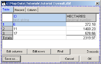
Step 3. Go to Utilities >– Database utilities > Generate database from DRA. Choose the new DRA file, result.dra.

In the dialogue box select the Area of polygon option and any other options that you want. Click OK.
Opening the database (Utilities > Database utilities > Edit database) you can read the total area in hectares. If you do the same with the original soils database you can determine the proportion of the soils area which is both of the selected soil type and the selected socio-economic category.