7.1 Introduction to land use planning - LUPMISManual
Main menu:
7.1 Introduction to Land Use Planning
Level of expertise required for this Chapter: Planner; specifically for LUPMIS @ TCPD
This Chapter gives an introduction to conceptual definitions of land use planning in Ghana, to be executed by the Town and Country Planning Department (TCPD). Detailed description of the planning approach is documented in the ‘models’ and ‘standards’ for each planning level. The following Chapters explain the pragmatic steps, how to execute the task to define land use plans, with strong emphasis on software handling. Planning can never be a ‘cookbook’ exercise, but this step-by-step, practical guide will help planners to design land use plans.
Important features in the urban planning process, such as stakeholder participation, financial considerations, socio-economic parameters, approval procedures and implementation steps are explained in detail in the aforementioned reports. Emphasis of this Manual is on ‘drawing’ of 'spatial land use plans', i.e. maps.
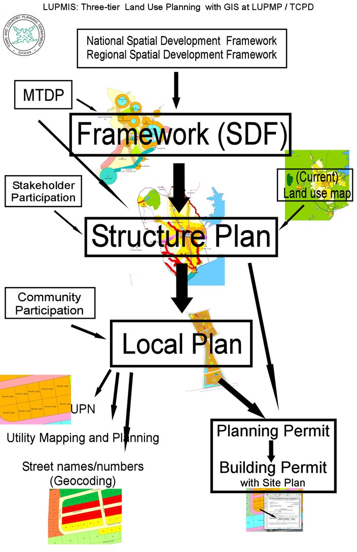
Economic planning is done in Ghana by the National Development Planning Commission (NDPC), while spatial, i.e. map-based, land use plans will be formulated by the Town and Country Planning Department on following three levels:
7.1.1 District Spatial Development Framework
(In the technical parts of this Manual referred to ‘Framework’, to avoid acronym-talk like ‘SDF’)
Definition: An indicative plan of districts, municipalities, metropolitan authority areas or regions, showing the expected development over a given time period, including the present and future proposed major land uses and transportation networks and the boundaries of areas of special planning concern along with the direction of further growth.
Spatial Development Frameworks are a graphical presentation of social and economic development policies with cartographic symbols.
They must be approved by the relevant political body (i.e. District Assembly). They can not be appealed by individuals.
Purpose: |
Identification of general locations of main land uses and transportation network under consideration of MTDP |
Full / alternative names: |
‘District Spatial Development Framework plan’, SDF, also called ‘Key Diagram’ or ‘Spatial Strategy’ with indicative maps called ‘Spatial Strategy Diagrams’ or ‘Key Maps’ |
Form: |
Report (long-term goals, economic plan etc – beyond the scope of this Manual) with accompanying maps |
Coverage: |
Nation, Region, District |
Type of map: |
Indicative |
Approximate scale, size: |
1:100,000 - 200,000 for Districts, |
Mapping features: |
Cartographic symbols such as corridors, circles, |
Planning type: |
Political document, ‘directives’ |
Input: |
National Spatial Development Framework (NSDF) |
Prepared by: |
District Planning Department in consultation with Sector Agencies and MMDA |
Revision: |
To be reviewed and adjusted in line with MDTP |
Change of unit(s): |
- |
The workplan (step-by-step guide) is explained in Chapter 7.4.2, the GIS process in Chapter 7.4.3.
7.1.2 Structure Plans
Definition: A plan for urban areas and their peripheries, showing present and proposed future development over a given time period and including major land uses, major roads, waterways and railway lines and all areas of special planning concern or interest, including conservation areas and areas of special ecological and environmental concern.
Structure Plans provide information about the future, general land use within specified boundaries, but allow flexibility within the areas with different classifications. (For example, school and local administrative offices and some small shopping areas are all acceptable within an area identified at structure plan level for residential). They are the main legal planning documents with ‘zones’ of development.
As they are legal, binding documents, they have to be approved by a technical and political process.
Purpose: |
Geographical (‘spatial’) delineation of major kinds of land uses, which serves as the basis for further planning, development and investment |
Full / alternative names: |
‘Master plan’ |
Form: |
Map with accompanying report (description of land use classes, year of implementation etc) |
Coverage: |
Township, village including surrounding area or similar |
Type of map: |
Geographically accurate (with error of + 10 m), general planning units |
Approximate scale, size: |
1:25,000 - 1:30,000, |
Mapping features: |
Spatially delineated units of major types of (approved) land use |
Planning type: |
Legal document, binding for further development and investment |
Input: |
- District Spatial Development Framework |
Prepared by: |
Land use planners, together with GIS staff, in consultation with major land owners, developers, utility companies and MMDA etc |
Revision: |
Every 5-10 years or as may be required due to unforeseen changes in requirements |
Change of unit(s): |
‘Re-zoning’ |
The workplan (step-by-step guide) is explained in Chapter 7.5.2, the GIS process in Chapter 7.5.3.
7.1.3 Local Plans (similar to earlier Sector Layouts)
Definition: A plan which proposes the disposition of land by function and purpose, including land for which the purpose has yet to be defined or to be preserved in its present state, to meet the present and future identified community needs within the time frame for the plan is valid.
Local Plans identify detailed land uses, down to parcel level, defined with strong community participation. They are tools to implement Structure Plans.
Like District Plans, they have to be approved by the local, technical and political authorities. They then form the basis for the issue of Planning Permits and Building Permits.
Purpose: |
Basis for parcel administration, land use management and permit issue |
Full / alternative names: |
Maps: ‘Sector Layout’ |
Form: |
Map (with accompanying description) |
Coverage: |
Sector, or relatively homogenous area of some 50-200 ha |
Type of map: |
Detailed, geographically accurate (with error of + 5 m), parcel-based |
Approximate scale, size: |
1:2,500, |
Mapping features: |
Parcels, and parcel-related features |
Planning type: |
Legal document, binding for parcel definition |
Input: |
- Structure Plan |
Prepared by: |
Architects, developers, engineers, together with land use planners and GIS staff |
Revision: |
Depends on structure plan revision, can also be on-demand |
Change of unit(s): |
‘Change of land use’ |
The workplan (step-by-step guide) is explained in Chapter 7.6.2, the GIS process in Chapter 7.6.3.
- - - - -
This three-level approach, which is recognized and practised in most countries of the world with a developed land use planning scheme, is graphically presented below.
Beside this use of the GIS as a drawing tool of land use plans at different levels and scales, there are two more functionalities, where GIS can be of assistance for land use planners:
Retrieval of spatial information: Support of land use planners at the decision making process. For example, data about the location of infrastructure (utility lines, schools, etc), but also quantitative, socio-economic data (population figures, death rate by region / district, etc) and area sizes. This option depends very much on the availability of relevant data (in process in Ghana), see also Chapter 1.4 for the procedure to query data, Chapter 1.5 for the procedure to measure, Chapter 4.3 for the procedure to retrieve database information. There will be further elaboration in future versions of this Manual.
Siting analyses: Selection of the best choice of a site for specific land use installation: If sufficient data are available (in process in Ghana), a site for a particular installation with high demand on ecology and neighbourhood constraint can be selected through a GIS modelling process (see Chapter 7.8, example, not-Ghana specific).
Access to parcel information: As permits form the implementation side of planning, issue and control of permits of land use is part of land use planning. GIS-controlled access to permit information is given to the permit database (see Chapter 7.7).
- - - - -
Don’t forget:
Though land use planning is based on defined methodologies, uses new technologies and requires accurate data, planning itself is not a science !
Spatial planning is ‘mapping of the future’.
Planning is a ‘manipulation for a better future’.
Urban planning starts with identification of (current and future) land-use related problems.
It is to answer the question, where people can find their housing and income, and not where they can’t.
- - - - -
Integration of this 3-tier planning system in the 'LUPMIS Tools' is shown in Chapter 8.1.
More reading:
GTZ: Land use planning

